![]() This AI is still in early stages of development.
This AI is still in early stages of development.
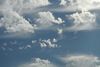
Clouds
- Aubergine
Cloud formation
Clouds are automatically placed and adjusted based on the following factors:
- Temperature
- Date / Time
- Geolocation of map
- Map topology
- Wind
For more specific details of which factors are used for each cloud, see list of clouds further down this page.
The higher the clouds, the fairer the weather. Basically, if clouds are mostly in the high-level, weather will usually be fair due to lack of clouds capable of producing rainfall or snowfall.
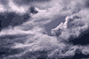
"When clouds appear like rocks and towers, the earth will be washed by frequent showers." – cumulonimbus.
Cloud types
| Extreme-level clouds (Mesospheric) | |||
| Photo | Name | Altitudes | Notes |
|---|---|---|---|
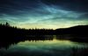 | Noctilucent
| 76→85km | Appearance: Thin and often very feint layer of wispy pale blue or silvery filaments. On are occasions they can appear green or red. Stars are usually clearly visible through the clouds. Conditions:
Precipitation: None. Weather: Typical summer weather. Forecast: Global climate change of the "Oh no, we're all going to die" variety. More info: Wikipedia, Crystalinks |
| Very high-level clouds (Stratospheric) | |||
| Photo | Name | Altitudes | Notes |
 | Nacreous
| 15→29km | Appearance: Thin layer of clouds, glowing brightly with vivid iridescent colours similar to those found in a seashell. Conditions:
Precipitation: None. Weather: Frigidly cold and icy, often with very little moisture in the atmosphere. Forecast: Ozone layer depletion. More info: Wikipedia, NamesOfClouds |
| High-level clouds (Tropospheric) | |||
| Photo | Name | Altitudes | Notes |
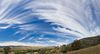
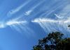
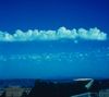
 | Cirrus
| 5→12km | Appearance: A wide variety of appearances but generally white, delicate-looking and "feathery". Usually translucent, but dense cirrus (formed from a cumulonimbus) can be opaque. Commonly move slowly in a westerly direction regardless of wind direction at ground level. Formation:
Precipitation: In rare cases, after a thunderstorm Cirrus may produce hail or large water droplets and will then dissipate completely. Occasionally produces snowfall virga. Weather: Usually fair. Forecast: Large numbers of cirrus clouds indicate an approaching warm weather front, or upper-air disturbance and troughs of low pressure, signalling the approach of stormy weather. See specific cloud forms for more details. Notes: When present in the jet stream, Cirrus can travel at over 100mph. However, they'll always appear to be slow moving in comparison to lower clouds even if the lower clouds are travelling much more slowly. More info: Wikipedia, Clouds-online, Nephology, Pilotfriend |
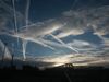
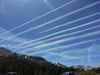
| Cirrus
| Variable ~5km | Appearance: Long, thin artificial clouds caused by condensation or fumes from airborne objects. Often called "contrails" (if non-persistent) or "chemtrails" (if persistent). Formation:
Notes: Can be used to determine the path taken by an aircraft or projectile. Precipitation: None. More info: Wikipedia |
 | Cirrus
| >6km | Appearance: A rarely seen series of dense lumps, or "towers" of Cirrus, connected by a thinner base. Looks a bit like crenellated battlements on old castles. Often accompanied by a thin veil of Cirrostratus. Formation:
Precipitation: May form snowfall virgas. Ground weather: Usually fair. Forecast: Impending rain or storms. More info: Wikipedia |
 | Cirrus
| >5km | Appearance: Fairly rare form of Cirrus arranged in superposed layers at slightly different levels, sometimes merged in places. Species: Most Cirrus fibratus and Cirrus uncinus exhibit this variety. Cirrus spissatus sometimes exhibit this variety. Notes: They tend to "chase" fair weather. Pictured: Cirrus fibratus duplicatus. More info: NamesOfClouds |
 | Cirrus
| >6km | Appearance: White or silvery clouds with fibrous threads or tufts at the ends. Often seen in two or more layers (duplicatus). They usually appear in small patches. Formation:
Precipitation: None. Ground weather: Usually fair. Forecast: Thick layers can be a precursor to rain or snow due to an approaching warm front, although this is rare. Thin layers generally indicate that fair weather (eg. Cumulus humilis) will follow, and in countries with tropical weather suggest a sunny day ahead. |
 | Cirrus
| >5km | Appearance: Small, usually isolated, tufts of pale white cloud, usually with a rugged base. Often seen with snowfall virga. Formation:
Precipitation: Usually virga, although on very rare occasions can briefly cause large rain droplets that reach the ground. Ground weather: Usually fair. Forecast: The presence of virga will sometimes give rise to storm cells by forming or contributing to Cumulonimbus. Notes: Cirrus floccus are the highest and fastest tropospheric clouds, often forming in the jet stream, although they will appear to be moving slowly when viewed from ground level. More info: Wikipedia |
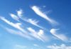
 | Cirrus
| >5km | Appearance: Tangled and interwoven filaments (streaks) and wisps of white, pale blue cirrus cloud. Unique to the cirrus genus. Species: Often associated with Cirrus spissatus. Formation:
Precipitation: None. Ground weather: Usually fair. Forecast: When present in large patches covering most of the sky, stormy weather will likely follow. Notes: This variety of Cirrus is usually the last to form, using up the last remaining moisture in the stratosphere. The air above them will be incredibly dry. More info: Wikipedia |
 | Cirrus
| >5km | Appearance: Parallel stripes or bands of pale white cloud, often covering the whole sky. They often appear to converge at a point on the horizon. Formation:
Ground weather: Usually fair. Forecast: Notes: Often accompanied by, and sometimes partly merged with, Cirrocumulus or Cirrostratus clouds. More info: Wikipedia |
 | Cirrus
| >6km (usually) >1.5km (sometimes) | Appearance: Opaque threads or whisps, ranging in colour from white to grey with increasing density. Often obscures the sun or moon. Sometimes seen in two or more layers (duplicatus). Notes: Unlike other Cirrus clouds, these can sometimes link to other, lower-level clouds such as Cumulonimbus, making their base drop well below the high-level part of the stratosphere (as low as 1.5km in some cases). Formation:
Ground weather: Generally fair, although if present with cumulonimbus there may be rain or snow. Forecast: Winds from the east travelling south will cause rainfall within 24 hours or less, winds in other directions will cause an overcast sky and often a storm within the next 48 hours. More info: Wikipedia, NamesOfClouds |
 | Cirrus
| >7km | Appearance: White clouds with "hooks" at one end, often seen in two or more layers (duplicatus). They are generally more thinly distributed than other Cirrus species (for example Cirrus spissatus). Formation:
Precipitation: Snowfall virga Ground weather: Usually fair. Forecast: Indicates approach of showers, rain, or possibly snow depending on temperature. |
 | Cirrus Ci * un | >6km | Notes: Not sure this classification is correct - looks more like a Cirrostratus undulatus. Appearance: Very rare Cirrus clouds with waves running through them. If there are two sets of waves interwoven with each other they are often referred to as "biundulatus". Formation:
Precipitation: Ground weather: Relatively cool or early stages of weather destabilisation. Forecast: |
 | Cirrus
| >6km | Appearance: White clouds in the distinctive form of a spinal column or fish skeleton. Unique to the cirrus genus. Conditions:
Ground weather: Usually fair. Forecast: Indication of changing weather. More info: Wikipedia |
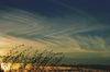
 | Cirrostratus
| >6km | Appearance: Milky, translucent cloud veil of ice crystals, which sometimes causes halo appearances around moon and sun. Often covers the whole sky. Formation:
Ground weather:
More info: Wikipedia, Clouds-online |
 | Cirrostratus
| >5km >8km | Appearance: Cirrostratus arranged in up to 12 superposed layers, at different altitudes, sometimes partly merged. Generally the thickest form of Cirrostratus, up to 8km thick, although each layer will usually be only a few hundred metres thick.
|
 | Cirrostratus
| >6km | Appearance: A thin layer of silvery or pale white fibrous veils. Unlike it's nebulosus counterpart, it will not cause halos around the sun or moon. Formation:
Weather: If no other clouds are present, the weather will usually be dry and mild. If other clouds are present, refer to their effects on weather conditions. Forecast: With falling air pressure, indicates approaching rain or storms within 8 to 24 hours. More info: Wikipedia, Clouds-online |
 | Cirrostratus
| >6km | Appearance: Very common smooth, light-grey, feint or fog-like veil that covers most of the sky. A "halo" may appear around the sun or moon due to light refraction in the ice crystals. Formation:
Precipitation: Does not produce precipitation or virga. Forecast: With falling air pressure, often accompanied by halo appearance, indicates approaching rain or storms within 8 to 24 hours. This is most common if Cirrus precede them, and Nimbostratus will usually start to form and subsequently lead to a storm. More info: Wikipedia, Clouds-online, Pilotfriend |
 | Cirrostratus
| >5km >8km | Appearance: Quite rare Formation:
Precipitation: Ground weather: Forecast: More info: NamesOfClouds, CloudAtlas |
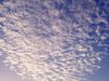
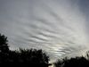
 | Cirrocumulus
| Appearance: High level milky-white cloud with wavelike or fine, dappled cumuliform structure. Formation:
Weather: Forecast: More info: Pilotfriend | |
Cirrocumulus
| Cirrocumulus, some elements of which are vertically developed in the form of small turrers, rising from a common horizontal base. The apparent width of the turrets is always less than one degree, when observed at an angle of more than 30 degrees above the horizon, the presense of this cloud is an indication of instability at its level. | ||
Cirrocumulus floccus
| Cirrocumulus composed of very small cumuliform tufts, the lower parts of which are more or less ragged. The apparent width of the tufts is always less than one degree, when observed at an angle of more than 30 degrees above the horizon. As in the case of Cirrocumulus castellanus, the presence of these clouds is an indication of instability at their level. Cirrocumulus floccus sometimes results from the evolution of Cirrocumulus castellanus the base of which has dissipated. | ||
Cirrocumulus <species>
| Cirrocumulus in a patch, sheet or layer, showing small more or less regularly distributed round holes, many of them with fringed edges. Cloud elements and clear spaces are often arranged in a manner suggesting a net or a honeycomb. | ||
Cirrocumulus lenticularis
| Cirrocumulus patches shaped like lenses or almonds, often very elongated and usually with well-defined outlines. These more or less isolated clouds are mostly smooth and are very white throughout. Irisation is sometimes observed on these clouds. | ||
Cirrocumulus
| Cirrocumulus in the form of a relatively extensive sheet or layer, sometimes showing gaps, breaches or rifts. | ||
Cirrocumulus <species>
| Cirrocumulus showing one or two systems of undulations. | ||
| Middle-level clouds | |||
| Photo | Name | Altitudes | Notes |
Altocumulus
| Formation:
| ||
 | Altocumulus
| Appearance: Cumuliform protuberances in the form of turrets which give this cloud a crenelated appearance (like the top of castle walls). The cumuliform cloud elements have a common horizontal base and appear to be arranged in lines. The castellanus character is especially evident when the cloud is seen from the side. Conditions:
Precipitation: None (normally) Ground Weather: Forecast:
More info: Altocumulus which presents, in at least a fraction of its upper part, cumuliform protuberances in the form of turrets which give this cloud a crenulated appearance. . The presence of this cloud is a sign of instability at its level; when it acquires a considerable vertical extent, Altocumulus castellanus becomes Cumulus congestus, and sometimes Cumulonimbis. | |
Altocumulus
| Altocumulus comprising two or more broadly horizontal superposed patches, sheets or layers, close together, sometimes partly merged. This variety occurs in the species stratiformis and lenticularis. | ||
Altocumulus
| Altocumulus consisting of small tufts if cumuliform appearance; the lower parts of these tufts are more or less ragged and are often accompanied by fibrous trails (virga of ice crystals). The presence of these clouds is an indication of instability at their level. Altocumulus floccus sometimes forms as a result of the dissipation of the base of Altocumulus castellanus. | ||
Altocumulus
| Altocumulus, in a sheet or layer or in patches showing more or less regularly distributed round holes, many of them with fringed edges. Cloud elements and clear spaces are often arranged in a manner suggesting a net or a honeycomb. The details change rapidly. | ||
Altocumulus
| A patch of Altocumulus, in the shape of a lens or almond, often very elongated and usually with well-defined outlines. This patch is either composed of small elements, closely grouped together, or consists of one more or less smooth unit. In the latter cased, there are pronounced shadings. Irisation is occasionally visible. | ||
Altocumulus
| A patch, sheet or layer of Altocumulus, the greater part of which is sufficiently opaque to mask completely the sun or moon, most often, the base of this variety of Altocumulus is even and its apparent subdivision into merged elements results from the irregularity of its upper surface. The uder surface is sometimes uneven and the elements then stand out in true relief. The variety opacus occurs fairly often in the species stratiformis. | ||
Altocumulus
| A patch, sheet or layer of Altocumulus in which the spaces between the elements allow the sun, the moon, the blue of the sky or higher clouds to be seen. This variety often occurs in the species stratiformis. | ||
Altocumulus
| Altocumulus showing approximately straight, parallel bands which, owing to the effect of perspective, appear to converge towards towards the horizon. | ||
Altocumulus
| Altocumulus in an extensive sheet or layer, composed of sperate or merged elements. This is by far the most frequent species. | ||
Altocumulus
| Appearance: A patch, sheet or layer of Altocumulus, the greater part of which is sufficiently translucent to reveal the position of the sun or moon. Species: This variety often occurs in the species stratiformis and lenticularis. | ||
 | Altocumulus
 composed of separate or merged elements, either elongated and broadly parallel, or arranged in ranks and files having the appearance of two distinct systems of undulations. Altostratus undulatus is more common. | |
Altostratus
| Appearance: Greyish or bluish sheet or layer of striated, fibrous or uniform appearance, totally or partly covering the sky, and having parts thin enough to reveal the sun at least vaguely, as through frosted glass. Altostratus does not show halo phenomena. Sometimes exhibits mammatus. Notes: Due to the uniformity of Altostratus clouds, they are not split in to species. Formation:
Precipitation: Can cause rainfall or snow virga, or continuous rainfall, snowfall or hail. | ||
Altostratus
| Altostratus composed of two or more superposed layers, at slightly different levels, sometimes partly merged. | ||
Altostratus
| Altostratus, the greater part of which is sufficiently opaque to mask the position of the sun or moon. | ||
Altostratus
| Altostratus showing broad parallel bands which appear to converge towards one point or towards two opposite points of the horizon. | ||
Altostratus
| Altostratus, the greater part of which is sufficiently translucent to reveal the position of the sun or moon. | ||
Altostratus
| Altostratus showing undulations. | ||
| Low-level clouds | |||
| Photo | Name | Altitudes | Notes |
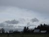
 | Stratus | Appearance: Low-lying formless cloud, greyish-white in colour. Conditions: Weather: Usually associated with cold, damp conditions in autumn, winter and spring. | |
 | Stratocumulus | Appearance: Low layered cloud with bumpy, heap-like structure. Conditions: Low elevation, slightly unstable airmass, slight upwards buoyancy convection, moderate moisture content, >0ºCWeather: A sign of blustery and relatively cool conditions indicating possible showers, rain or snow. | |
| Cumulus | |||
 | Cumulus humilis
|
| Appearance: Small heaps of clouds with flattish bottoms and rounded tops. Conditions: Low elevation, slightly unstable airmass, slight upwards buoyancy convection, small moisture content, >0ºC Weather: Usually a sign of fair (nice) weather when they appear in clear sky. If cirrostratus clouds are also present, a warm front is approaching, expect showers in the next 12-24 hours. Forecast: If these clouds are present in the morning it is a sign of an unstable atmosphere. Larger clouds and possibly thunderstorms could form throughout the day to cause bad or severe weather in the afternoon or evening. Temporal: Most common in the afternoon near the top of the well-mixed planetary boundary layer. More info: Wikipedia |
Cumulus Cu med | |||
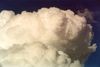 | Cumulus congestus | Appearance: Very active separated heaps with flat bottoms (usually) and growing towers. Often called "summertime clouds". Formation:
Weather: Transient showers Forecast: | |
 | Pyrocumulus
| Ground-level | Appearance: Cumuliform smoke plume, often greyish-brown in colour. Conditions: Intense fire on the ground. Location: Site of a laser satellite strike, nuclear explosion, plasmite bombs, etc. Weather: Significant plumes (Pyrocumulonimbus) can cause lightning. Forecast: As they spread they can cause other clouds to form. More info: Wikipedia |
| Multi-level clouds | |||
| Photo | Name | Altitudes | Notes |
 | Cumulonimbus |
| Appearance: A massive pile of cloud penetrating the freezing level and sometimes forming an anvil at the base of the stratosphere. |
 | Nimbostratus | <3km | Appearance: Generally formless dark mass of low- to middle-level storm cloud. Generally obscures the sun and moon. Supplementary and Accessory: (praecipitatio), (virga), (pannus) Formation:
Precipitation: Light to moderate, and sometimes heavy, rainfall or snowfall, which is generally steady and prolonged. Notes: Stratus and Stratocumulus will often form below Nimbostratus, especially as it clears. The Stratocumulus clouds will sometimes thicken due to precipitation from the Nimbostratus and causing them to mutate in to Nimbostratus in the lower-level atmosphere. In addition, the conditions required for Nimbostratus also cause high-level clouds to form. Forecast: Grim weather over prolonged period of time, often giving way to Stratus or Stratocumulus clouds when the weather clears. More info: Wikipedia, Pilotfriend |
| Additional features and accessory clouds | |||
| Photo | Name | Height | Notes |
(asperatus) * (asp) | http://en.wikipedia.org/wiki/Undulatus_asperatus An additional feature sometimes found with Stratocumulus stratiformis undulatus or Altocumulus stratiformis undulatus. | ||
(arcus) * (arc) | Often called roll or shelf cloud: a dense, horizontal roll with more or less tattered edges, situated on the lower front part of certain clouds and having, when extensive, the appearance of a dark, menacing arc. | ||
(incus) * (inc) | The upper portion of a Cumulonimbus spread out in the shape of an anvil with smooth, fibrous or striated appearance. Formation:
More info: Pilotfriend | ||
 | (mammatus)
| Appearance: A cellular pattern of pouches hanging underneath the base of a cloud, often a cumulus or cumulonimbus. Sometimes seen under cirrus clouds, in which case only the bottom part of the pouch is visible. Conditions: Warm weather, moist unstable upper atmosphere over very dry lower atmosphere, upwards buoyancy convection. Weather: Forecast: More info: Wikipedia | |
 | (pannus) * (pan) | Ragged shreds, sometimes constituting a continuous layer, situated below another cloud and sometimes attached to it. | |
(pileus) * (pil) | An accessory cloud of small horizontal extent, in the form of a cap or hood above or attached to the top of a cumuliform cloud which often penetrates it. Several pileus clouds may fairly often be observed in superposition. | ||
(praecipitatio) * (pra) | Precipitation (rain, drizzle, snow, ice pellets, hail, etc.) falling from a cloud and reaching the earth's surface. | ||
(tuba) * (tub) | Cloud column or inverted cloud cone, protruding from a cloud base; it constitutes the cloudy manifestation of more or less intense vortex, and if it touches the ground can become a tornado or waterspout. | ||
(velum) * (vel) | An accessory cloud veil of great horizontal extent, close above or attached to the upper part of one or several cumuliform clouds which often pierce it. | ||
(virga) * (vir) | Appearance: Vertical or inclined trails of precipitation ("fallstreaks") attached to the under surface of a cloud, which do not reach the earth's surface. Conditions: Precipitation (pra) that evaporates as it encounters warmer air below. Location: Common in the desert and in temperate climates. In North America, it is commonly seen in the Western United States and the Canadian Prairies. Forecast: Can cause formation of Cumulonimbus clouds which in turn cause stormy weather. More info: Wikipedia Variants: When a virga occurs in a Cirrocumulus or Altocumulus cloud, a "fallstreak hole" may occur. Aircraft passing through the clouds often trigger the virga, a useful cue for you to start building AA defences! More info: Crystalinks, Wikipedia | ||
(fallstreak hole) (holepunch cloud) | |||
| (wall cloud) | |||
| (flanking line) | |||
Earthquake lights
It might be possible to implement earthquakes in Warzone, using a camera shake and health damage to DEFENCE structures (walls, towers, etc). If so, an interesting associated phenomena could be earthquake lights - iridescent colouring sometimes seen in the sky before, during and after an earthquake:
Still under construction, possibly lots of errors so check interwebs for verification.